Saturday, January 26, 2008

Sunday 20th January
Decisions, decisions. We had two possible routes to go from Wellington at the southern tip of the North Island. Up the middle through Rotarua or to the East Coast and Napier. We decided to give Rotarua a miss although it’s reckoned to be a major attraction it also has the reputation of being highly commercialised and the ocean always has a lure for us.
So up the Hutt valley we went, through Upper Hutt, Masterton and Dannevirke towards Napier/Hastings. We ended up at a strange ‘remote’ campsite at a tiny place on Highway 50 called Tikokino. The campsite was in a field off the road with a gate which was closed but not padlocked, toilet and kitchen facilities with no electricity or running water and no indication of other people or how to pay. There was a hotel next door which was ‘closed for reservations’ and no way of getting into the building. The field had been recently mowed so we thought what the heck and parked. Nobody came to demand payment or anything so we had supper and went to bed. Then, in what seemed to be the middle of the night (it was still pitch dark) we woke to a rumbling very close, too close for the road, the sound of voices and bright lights flashing all around. Timidly we pulled back the curtains to see this massive wooden building being backed into the field where we were. That kind of ruined the rest of our night’s sleep but as it was actually 5 o’clock we didn’t suffer too badly.

Turns out a house moving company was moving the following structure (the mustard coloured thing on the right) as cabins to add to the campsite.

We were amazed at what it must have taken to get it there down the narrow New Zealand roads from Hastings, it had to be almost a hundred feet long (you only see about a third of it in the picture). No wonder they did it at night.
Monday 21st January
Around our usual breakfast time they started bringing more equipment into the field, to get the thing off I suppose. So before we could get blocked in, we upped stakes and hit the road. Before too long we were driving into Napier down this palm tree-lined street.

Hitting the sea front we came across the National Aquarium so we had breakfast in the parking lot and then went inside. Well worth the reasonable entry fee. We were in time for the feeding. The walk through the oceanarium was the best, as can perhaps been seen from this clip.
Sea horses are always worth a look.
They had kiwis too, but photography totally failed (flash again not permitted) as they have reversed the kiwis’ day and night so you get to see them in their night in very low light.
Here’s a guy we’ve eaten plenty of in NZ – a gurnard.
With lots of distance to travel (time’s a runnin’ out) we were off by mid-day and headed up the coast through Wairoa and Gisborne, heading for remote campsites just north of Gisborne. Turihaua has a big remote camping area down on the shore, unfortunately we found, after getting there, that we needed a camping permit available only in Gisborne. As we had no intention of driving all the way back we just stayed anyway for free - yet again.


Tuesday 22nd January
After a walk along the beach

we were moving again through Tolonga Bay, Tokomaru Bay, Ruatoria and Te Araroa looking in vain for Internet access so we could contact Alan Littler aka Charlie, a schoolfriend I haven’t seen in 32 years, who was arriving in Mount Maunganui that very day. The trip probably should have been spectacular but as before the North Island did not co-operate weatherwise and it was misty and rained continuously with little or no visibility.
The first place we stopped for the night at Waihau Bay turned out to be very expensive with no credit card use, so we passed on that and ended up at Te Kaha which is reasonably priced and has exceptionally beautiful grounds.

Friday 25th January
We had breakfast with a lady originally from South Africa but now a confirmed Kiwi who had stayed at the Chipman Hill Suites in St. John, New Brunswick where we stayed before setting out on this epic journey. Susan Fullerton who owns the suites put us in touch with her and we had boiled eggs and scones with Elvor Shaw and heard some of her continuing travel stories.
Times a really runnin’ out and we had the Coromandel peninsular to visit and on Elvor’s recommendation we headed for Hahei to pay the most we’ve ever had to pay for a campsite on the whole t ri p – 20 bucks each and no power but it was on a fabulous beach

 
And I had several out-of-body-surfing experiences like never before. I also got rolled a couple of times as the waves were well above head height.
Saturday 26th January
Just when you think New Zealand has nothing new to show you along comes things like this.
This is Cathedral Cove – named for obvious reasons. We caught it at high tide and apparently there isn’t any surf like that normally.

Onwards we went after the walk (1½ hours round trip) and after crossing the peninsula to Coromandel Town, found another little gem of a campsite at Tapu Creek on the west side of the Coromandel Peninsula. Beautiful setting

complete with swimming hole

outdoor kitchen
doves

lonely bullock
and new clean facilities.
Sunday 27th January
Last day before flying to Oz. Given all or most of our leftover food etc. with other campers and down the last of the Coromandel Peninsula and on to the major highways and in a couple of hours we’re at the hotel unloading the campervan ready to return it. Campervan returned with 8,481km more on its clock. Now all we have to do is pack for tomorrow and catch the ’plane at 7:50 am.


The loop is complete.

Saturday, January 19, 2008

Tuesday 15th January

After a lazy day in Christchurch going basically nowhere, other than a trip to the Britz (campervan company) depot to get the battery charger replaced and some shopping we stayed a second night with Jane, John and family.

After final goodbyes to the Forrest family
with the expectation we may see some, or all of them in Brisbane, Australia, in March. We left Christchurch via a trip to the Antarctic Centre to see Blue penguins. They are the cutest little fellows you ever did see. All the ones at the centre have been rescued from the wild and are damaged in some way (in the movie you’ll see one with only one foot swimming in circles) and unable to survive in the wild again.

And rode a Hägglund or Antarctic all-terrain vehicle.

There was also a nifty demonstration of the earth’s rotation and how it affects where the sunlight falls – see the video on the right hand side of the blog if such things interest you.

Wednesday 16th January

Our final destination that day was Hanmer Springs. famous for its thermal hot springs which we sampled the next day after a 3 hour walk/climb to YABW (yet another beautiful waterfall).

We eased our aching muscles in the 40degC sulphur springs and then, although quite late in the day for us, did a 200k trip to Lake Rotoroa (not to be confused with Rotorua in the North Island) via Murchison and a remote campsite on the shores of the lake.

Beautiful place but the sandflies are unbearable. There is a Maori legend that says that a goddess was afraid that New Zealand (especially the South Island) was too much like paradise and everyone would just sit around doing nothing, so she inflicted the sandfly (or blackfly) to make sure they didn’t. The other version is that the goddess of the underworld figured she wouldn't have any customers because it was so pleasant up here. Either way they are a royal pain.

Thursday 17th January

For those who’ve been following the plot so far you may remember us meeting a couple at Mount Cook (Brian and Rosie ) who invited us to park at their place when we were in Nelson. So, from Lake Rotarua we headed East and North to Nelson and had some beach time (really for the first time) at Tahunanui Beach where the seawater was actually warm.

We knew Brian and Rosie were only coming back that day, so we didn’t get to there place until around five but the house was still deserted. We parked on the verge opposite the house, got out the folding chairs, I cracked a beer open and right then they rolled up. We had supper altogether in their lovely place overlooking the bay
and made plans for the next day. They suggested we took a trip to the Abel Tasman National Park and as other people had recommended the same thing we decided to do that.

Friday 18th January

So the next day, later than we should have, we set out for Kaiteriteri to find a water taxi to take us up the coast as there is no road access into the park. We arranged to be taken up the coast to Awaroa Bay and then, after we had walked back via Tonga Bay, to be picked up four hours later at Bark Bay.

The ride up (and back down) was a blast.
We were dropped at Awaroa Bay and we walked up to the lodge there first before setting out on the trek. The lodge grows most of its own vegetables and herbs in a huge garden.

The walk was probably the best we’ve had, climbing high above the fantastic beaches and deep blue ocean through fern forests with the constant loud buzz of NZ cicadas.

We lunched in a camping area on Tonga Beach and just made it in time for the taxi back.

Sailboats everywhere, anchored out off sandy beaches and rocky islands and some high and dry when the tide is out. We met all sorts of people doing the trek from different points, some camping overnight.

Back in Monaco (a suburb of Nelson) where Brian and Rosie live, we had excellent fish and chips from somewhere local to end a perfect day and one of the highlights of our trip.


Saturday 19th January

The morning of the 19th and we were booked on the 2:25 ferry from the South Island back to the North. Brian and Rosie (and Ned who's really Nadine)

recommended their local pub (checkout the name) for a good breakfast

and they were right. Then it was on the road again from Nelson to Picton, on probably the most winding road yet and it was goodbye South Island - we will miss you.


Right now we’re back in the Top Ten site in Lower Hutt on the North Island and have 24hrs of Internet for 10 bucks – woo hoo.


Current progress:

Sunday, January 13, 2008

Well we did get to see Albatrosses, though you couldn’t say we got up-close and personal. As yet another endangered species, they are kept under strict control, or should I say the tourists are. The Albatrosses are incubating their eggs at this time of year and there really isn’t too much activity. You are behind glass and quite a distance away (can you see an Albatross?).

In the late 1800’s the New Zealander’s were afraid of a Russian invasion and so they had the famous ‘disappearing gun’ manufactured and installed on Taiaroa Head. It’s an amazing contraption that used a hydraulic fluid of soapy water to raise and lower the beast in very short order.
It was never used in anger but was fired over 400 times.

In the afternoon we took a trip to Allans Beach on the way back to Dunedin. It’s a beautiful beach were yours truly took another chilly swim.

But the best part was our seal encounter.

And then we got the following display by some birds fishing in the surf.

After some much needed stores replenishment in Dunedin we headed up the coast through Palmerston, aiming for a campsite shown on our map at a place called Shag Point. The campsite turned out to be fictitious so we parked right next to the beach in a rest area and went to sleep to the sound of surf and passing trucks and the occasional train.

The next day sent us in search of penguins at a place called Oamaru where they have both blue and yellow eyed penguins. Our timing was bad as most of the day is spent at sea for the penguins and their chicks are hidden up on the high cliffs in holes and the brush. Can you spot the chick in this picture?

It was just as hard to see in real life.

After Oamaru we turned back inland again from the coast in the direction of Mount Cook. On the way we stopped at an unmanned campsite on Lake Benmore at Sailor’s Cut. This place was a sea of permanent tents and caravans, the most crowded place we’ve seen. You can buy a season pass for 300 bucks so you can see the appeal.

From there we continued our northerly route through Omarama and Twizel (pronounced twyzel) to stay on Lake Pukaki at the campervan site closest to Mount Cook after we’d done a preliminary trip to the Tasman Glacier. The glaciers here are very different to Fox and Franz Josef. For a start you approach the whole Mount Cook experience down a wide flat valley with little or none of the tortuous stuff of the Western side of the Southern Alps. The glaciers also end in lakes with protruding ice. The ice is not floating and the colour of the water is just as it appears.

We got to see three glaciers here, the Tasman (the biggest in New Zealand)

the Hooker

and the Mueller.


We later found out that we were at Mount Cook exactly on the day of Sir Edmund Hillary’s death. This is the centre that bears his name which looks out over the mountain.We met two other couples on the Glentanner campsite, Bert and Elizabeth from Thunder Bay Ontario who are a spry pair in their eighties and Brian and Rosie from Nelson in the South Island. We have Brian and Rosie’s address in Nelson and an invite to drop by on our way through. The four of them met some years ago and get together whenever they can.

We did a long walk on the Friday and ended up a little sunburned and tired. However, move on we must, as we plan to be in Christchurch on Sunday night, so here we are right now Saturday 12th January in the Lake Tekapo Holiday Park after driving back down beside Lake Pukaki and round the bottom end where the most magnificent views of Mount Cook are to be seen.

The colour of the water is not a photographic aberration; the lake is fed by glacial water containing minerals gouged from the rock by the glacier itself, giving the water this beautiful colour.

Lake Tekapo is a small town on the lake of the same name with an observatory which we took a look at. The Mount John Observatory is New Zealand’s most southerly observatory and the world’s most southern optical observatory. There are actually multiple telescopes on the mountain

and on our tour one of the other participants had actually protested the building and use of a US telescope to monitor Russian satellites during the cold war. We were shown the largest telescope which is actually owned by the Japanese (note the colours) and is used for a project called MOA (Microlensing Observations in Astrophysics). We got a short lesson in astro-physics from our guide which made perfect sense at the time. Although it is a true optical telescope you really don’t look through it, it has a helium cooled digital camera at the business end with a LOT of megapixels and they scan the night sky taking photographs of stars which are then processed by supercomputers looking for planets in other solar systems. The following link tells all: www.phys.canterbury.ac.nz/moa/moa_telescope.html

Next place on the list was Peel Forest where there is a (noisy – lots of youngsters) full service campsite which we arrived after driving through Fairlie and Geraldine.

We met Malcolm and Dawn Pearson from Lyttleton near Christchurch on the campsite. Malcolm it turns out had spent his working life in the merchant marine after going to sea as a young boy on one of the last square-rigged vessels to be used for cargo transport. The ship was the Pamir, taken from the Fins in WWII and used by New Zealand. Here’s a pic.

You can find more at: http://en.wikipedia.org/wiki/Pamir_(ship)

Next morning (Sunday Jan 14th) we took what we thought would be a three hour hike that turned into the most arduous trek we have done yet – hands and knees stuff. However, it we saw some interesting vegetation like this fern/tree. Is it a tree or a fern?

The forest is also home to some 1000 year-old Totara trees, this not being the biggest (that one is 3 metres in diameter).

After the walk we headed on to Christchurch to call in on John and Jane Forrest and family where the Internet is plentiful and free (to us). Oh yes, and the food and wine are also plentiful.


Latest progress:

Monday, January 7, 2008

From Te Anau we made the trek north to Milford Sound, so named by the Welshman who found it and named it after his home port of Milford Haven. The thing to do there is to take one of many cruises on the Sound which is strictly a fiord (fjord if you will) and not a ‘sound’. A ‘sound’ is created by a river; a fiord is created by ice. On arriving we found they were all booked up until two days later so, not wishing to make the arduous trek back, we decided to stay in a campsite for a whole day and not drive anywhere – a first.

The drive there is an experience in itself as the road winds up high mountain passes and back down into valleys surrounded by precipitous peaks. We got see Kea in one high spot – a New Zealand parrot.


Then as you drive along one valley towards a mountainside you realize there is no way out as a hole appears ahead of you in the cliff side.

The tunnel is 1.5km long and is essentially one-way and on a very steep grade. And the steep grade continues on down to sea level on the other side. So steep that we gave a ride down to someone who figured his brakes were shot, only to be told by his rental company that he should just let it cool down and use the gears to slow him down. In spite of using a low gear all the way I could smell burning brake pad on our van.

Once we got there and went on the cruise, this is the vessel we traveled on:

However, it turns out that we were quite lucky, it only rains like that about 3 times a month (annual rainfall over 7 meters) and it makes the waterfalls nothing less than breathtakingly spectacular. The mountains on either side are thousands of feet high and the water cascades off them everywhere.

The cruise takes you out of the sound into the Tasman Sea and at that point the weather started to clear and on the way back blue skies and sunshine finally penetrated. We stopped in on the way back at the underwater observatory which is basically a cylinder poking down the first 20 meters into the 300 meter depths of the fiord. It seems that the top layer of the water in the fiord is fresh, sometimes going down several meters (15 in 2004). As the water has been dyed by the minerals from the mountains it makes the fish think they are deeper down than they are, so although the viewing point is not that deep you get to look at fish that would normally be on the ocean floor.


The cylinder is surrounded by man-made trays of sea creatures that they can move up and down to compensate for the depth of the fresh water.

Once back on shore we set off on our way back towards Te Anau, stopping on the other side of the Homer Tunnel to do a bit of mountain climbing. On the way up we’d seen snow and I wanted to go take my picture on it.


More waterfalls of course that actually become a river that is flowing under the snow.

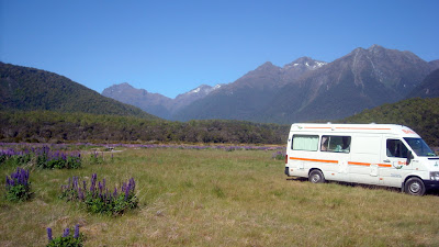
We stopped for the night at a remote campsite in a field filled with lupins – Cascade Creek – next to a river in a valley surrounded by the Southern Alps.

Moving on we next stopped at the Lake View (there’s an awful lot with this name) campsite in Manapouri which is the location for trips to Doubtful Sound. Getting to Doubtful Sound involves a boat trip followed by a bus trip followed by the cruise and is pretty expensive (over 200 bucks each) and was fully booked up anyway. It’s a very picturesque spot on a beautiful blue lake.


The next day (5th Jan) we headed down to Bluff at the very Southern tip of the New Zealand South Island. On the way we passed the historic Clifden wooden suspension bridge (thankfully no longer used for vehicles).


Bluff claims to be the oldest town in New Zealand (closest to Australia) and still acts as the port for Invercargill.

There is another large island off the coast (Stewart Island) but it has no real roads and is strictly for tramping (NZ term for hiking). Bluff has a great unmanned campsite close to the shore, that has power for all sites and beautiful facilities. We ended up staying there two nights for Carol’s birthday so we could go to the local restaurants. As her birthday present there was no cooking or washing-up, we had every meal out. Breakfast started out at “Stella’s”


lunch and supper were at Land’s End

where the food was great and the hospitality even better.

We took a drive to the lookout at the top of the highest hill around.

And we also followed one of their walks along the coast for an hour or two. All in all a very pleasant day.

The next morning we awoke to rain, but that’s was OK as we needed to get to Dunedin, over 200 km – a big drive for us. We took the coast route, back through Invercargill, Tokanui, the Catlins rain forest reserve, Owaka, Balclutha and Milton, then through Dunedin out on to the Otaga Peninsula (on a windy coast road, in some places about 2 feet from a drop into the water with no guard rails), to Portobello and the Portobello Village Tourist Park. After supper we took up a nearby hill and took a couple of pics looking down on the village and the Portobello peninsula.


Today we go to see Albatrosses.


Latest progress: