From Te Anau we made the trek north to Milford Sound, so named by the Welshman who found it and named it after his home
port of Milford Haven.
The thing to do there is to take one of many cruises on the Sound which is strictly a fiord (fjord if you will) and not a ‘sound’.
A ‘sound’ is created by a river; a fiord is created by ice.
On arriving we found they were all booked up until two days later so, not wishing to make the arduous trek back, we decided to stay in a campsite for a whole day and not drive anywhere – a first.
The drive there is an experience in itself as the road winds up high mountain passes and back down into valleys surrounded by precipitous peaks. We got see Kea in one high spot – a New Zealand parrot.

Then as you drive along one valley towards a mountainside you realize there is no way out as a hole appears ahead of you in the cliff side.

The tunnel is 1.5km long and is essentially one-way and on a very steep grade. And the steep grade continues on down to sea level on the other side.
So steep that we gave a ride down to someone who figured his brakes were shot, only to be told by his rental company that he should just let it cool down and use the gears to slow him down.
In spite of using a low gear all the way I could smell burning brake pad on our van.
Once we got there and went on the cruise, this is the vessel we traveled on:

However, it turns out that we were quite lucky, it only rains like that about 3 times a month (annual rainfall over 7 meters) and it makes the waterfalls nothing less than breathtakingly spectacular.
The mountains on either side are thousands of feet high and the water cascades off them everywhere.
The cruise takes you out of the sound into the Tasman Sea and at that point the weather started to clear and on the way back blue skies and sunshine finally penetrated. We stopped in on the way back at the underwater observatory which is basically a cylinder poking down the first 20 meters into the 300 meter depths of the fiord. It seems that the top layer of the water in the fiord is fresh, sometimes going down several meters (15 in 2004). As the water has been dyed by the minerals from the mountains it makes the fish think they are deeper down than they are, so although the viewing point is not that deep you get to look at fish that would normally be on the ocean floor.
The cylinder is surrounded by man-made trays of sea creatures that they can move up and down to compensate for the depth of the fresh water.
Once back on shore we set off on our way back towards Te Anau, stopping on the other side of the Homer Tunnel to do a bit of mountain climbing. On the way up we’d seen snow and I wanted to go take my picture on it.


More waterfalls of course that actually become a river that is flowing under the snow.
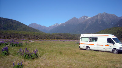
We stopped for the night at a remote campsite in a field filled with lupins – Cascade Creek – next to a river in a valley surrounded by the Southern Alps.
 Moving on we next stopped at the Lake View (there’s an awful lot with this name) campsite in Manapouri which is the location for trips to Doubtful Sound. Getting to Doubtful Sound involves a boat trip followed by a bus trip followed by the cruise and is pretty expensive (over 200 bucks each) and was fully booked up anyway. It’s a very picturesque spot on a beautiful blue lake.

The next day (5th Jan) we headed down to Bluff at the very Southern tip of the New Zealand South Island. On the way we passed the historic Clifden wooden suspension bridge (thankfully no longer used for vehicles).

Bluff claims to be the oldest town in
New Zealand (closest to
Australia) and still acts as the port for Invercargill.
There is another large island off the coast (Stewart Island) but it has no real roads and is strictly for tramping (NZ term for hiking). Bluff has a great unmanned campsite close to the shore, that has power for all sites and beautiful facilities. We ended up staying there two nights for Carol’s birthday so we could go to the local restaurants. As her birthday present there was no cooking or washing-up, we had every meal out. Breakfast started out at “Stella’s”

lunch and supper were at Land’s End

where the food was great and the hospitality even better.

We took a drive to the lookout at the top of the highest hill around.

And we also followed one of their walks along the coast for an hour or two.
All in all a very pleasant day.
The next morning we awoke to rain, but that’s was OK as we needed to get to Dunedin, over 200 km – a big drive for us. We took the coast route, back through Invercargill, Tokanui, the Catlins rain forest reserve, Owaka, Balclutha and Milton, then through Dunedin out on to the Otaga Peninsula (on a windy coast road, in some places about 2 feet from a drop into the water with no guard rails), to Portobello and the Portobello Village Tourist Park. After supper we took up a nearby hill and took a couple of pics looking down on the village and the Portobello peninsula.

Today we go to see Albatrosses.
Latest progress:


 The tunnel is 1.5km long and is essentially one-way and on a very steep grade. And the steep grade continues on down to sea level on the other side. So steep that we gave a ride down to someone who figured his brakes were shot, only to be told by his rental company that he should just let it cool down and use the gears to slow him down. In spite of using a low gear all the way I could smell burning brake pad on our van.


 Moving on we next stopped at the


 where the food was great and the hospitality even better.
 And we also followed one of their walks along the coast for an hour or two. All in all a very pleasant day.

